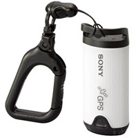
Sony's new GPS-CS1 is compact device (about 55 g) that records your GPS coordinates every 15 seconds while in the field. Then, when you return home, you can synchronize this information with your picture metadata and know the approximate location of every image you captured.
The $150 USD device works with Sony Cyber-shot DSC-S500, S600, S45, W30, W40, W50, W70, W100, H2, H5, T30 and Sony α (alpha) DSLR-A100 cameras using Windows software. It's not clear yet if it can be used for other cameras via a workaround. We'll have to wait until it actually ships to find out.
In the meantime, this is probably the first of many such devices we'll see that enable us to record satellite data and synch it with our image metadata.
Technorati Tags: equipment, digital photography, gadgets


FWIW, you can do the same thing with any camera using any handheld GPS, bluetooth GPS, or wired GPS that includes the ability to transfer a track to the computer (most models can). Price is as low as $50-75 and the software to to synchronize the information is available for Windows and Mac (and possibly Linux) for free.
I forgot to mention as an example that I've successfully done this using a Magellan eXplorer 400 and GPSPhotoLinker for the Mac (http://oregonstate.edu/~earlyj/gpsphotolinker).
My hobby is paraglider and GPS device is required for flights. This is a very popular device from paraglider.