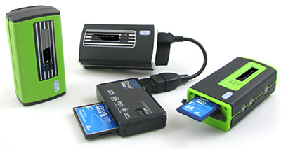
Since we don't have Geotagging in most of our cameras yet, here's a slick device for SD Card shooters that enables us to add GPS position data directly to JPEGs. ATP's Photo Finder is a pocketable GPS tracking device that lets you insert the SD memory card from your time-synced camera, then it writes the positions directly to the file header of each shot. You can then plot the data with Google Earth to see the location of each photo.
The $100 device seems easy enough to use. Just make sure that your camera's internal clock is in sync with the Photo Finder, and that the device is on while you're out taking pictures. When you take a break, just remove the SD card from your camera, insert it in Photo Finder, and the data is added to each shot. Later, when you upload the images to your computer, you'll see the GPD info in the EXIF data.
If you shoot RAW, my guess is that you'll have to shoot RAW+JPEG and use Photo Finder for the companion files. Also, it doesn't accommodate CF Cards directly, but as shown in the illustration, can tag them via a USB memory card reader. This is an interesting device that I want to explore more.
If you have any experience with it, please post a comment.
Technorati Tags: digital photography, gadgets, Technology, The Digital Story, GPS, Geotagging


Maybe its me- but why should I want to geotag my images? I have more info about my images than I will ever need. What are the practical applications for this if any?
I haven't used this, but I've got an effective solution on my Mac using a regular Garmin GPS ($100) and HoudahGeo software on my Macintosh ($30) to do the same thing - HoudahGEO writes to RAW files just fine, it works with the files on the computer so no worries about the flash card format, and the GPS unit is any regular gps unit that logs tracks, so you can use the unit without the camera as well :)
GeoTagging my photos with HoudahGeo is now part of my workflow before bringing them into Lightroom.
As to why I geotag, I like seeing exactly where on a backroad I stopped to take a picture of what interested me.
@Scott:
what model Garmin are you using?
this is exactly the workflow i am looking for ...
@Brett - I was using a Garmin eTrex, I've since moved to a Magellan Explorist 500.
There's a freeware program for OS X called Load My Tracks that loaded the track data from both units without any problems - it will export to GPX format and KML (Google Earth) as well.
Not quite as all-in-one as the ATP product above, but I find it doesn't take much effort as part of my workflow.
Have you checked out the Blue2CAN by Red Hen Systems:
https://ecommerce.redhensystems.com/pc-47-2-blue2can.aspx
Blue2CAN is an integrated solution for GeoTagging digital still images with GPS data. Using a BlueTooth enabled GPS unit and industry leading Nikon D200, D2X, D2Xs, D2Hs, D3 and D300 product lines. Blue2CAN allows users to directly capture geospatially referenced images in the easiest, most reliable collection method today. Geo-spatial information (Lat, Lon, UTC etc.) collected from the GPS receiver is encapsulated in metadata tags of every image taken. For JPG files the geo-spatial data is contained in the industry standard EXIF tags, for RAW files the metadata is maintained by RAW image workflows and is put in EXIF tags when RAW files are converted to JPG.
Blue2CAN plugs directly into the 10 pin connector on the front of the camera without the use of cables. It uses a small amount of power from the camera to operate it's BlueTooth radio and connects automatically to any BlueTooth enabled GPS receiver in near proximity. There is "zero configuration" required, just plug it in, turn on your GPS receiver and start shooting, not buttons to push except the shutter!
The Blue2CAN for GeoTagging Pictures
https://ecommerce.redhensystems.com/pc-47-2-blue2can.aspx
The Blue2CAN is an integrated solution for GeoTagging digital still images with GPS data. Using a BlueTooth enabled GPS unit and industry leading Nikon D200, D2X, D2Xs, D2Hs, D3 and D300 product lines. Blue2CAN allows users to directly capture geospatially referenced images in the easiest, most reliable collection method today. Geo-spatial information (Lat, Lon, UTC etc.) collected from the GPS receiver is encapsulated in metadata tags of every image taken. For JPG files the geo-spatial data is contained in the industry standard EXIF tags, for RAW files the metadata is maintained by RAW image workflows and is put in EXIF tags when RAW files are converted to JPG.
Blue2CAN plugs directly into the 10 pin connector on the front of the camera without the use of cables. It uses a small amount of power from the camera to operate it's BlueTooth radio and connects automatically to any BlueTooth enabled GPS receiver in near proximity. There is "zero configuration" required, just plug it in, turn on your GPS receiver and start shooting, not buttons to push except the shutter!
Thanks so much for this awesome article, This is exactly the thing I needed to read!
Very good post. Thanks for sharing.