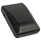
Put that empty hot shoe to work with the just-announced Jobo photoGPS, a $159 Global Positioning System (GPS) receiver that is triggered by the hot shoe contact on your camera. The "device allows automatic geo-tagging by capturing raw GPS data and time which enables new and more efficient ways to search, visualize, and share photo collections," reports PCPhoto.
Jobo is launching the product with Windows software to sync data with your images, but a Mac OS X version is promised by the end of the year. If it turns out to be reasonably easy to use, this could be a good geo-tagging solution all levels of photographers. It might even be a nice solution for my Canon G9.
Technorati Tags: Derrick Story, digital photography, GPS, Technology, The Digital Story












I had asked once before here- what is really the usefullness of geo tagging? Other than the "neato" factor, what would be real world applications for this? Obviously I can see if your a globe traveling journalist, but for the rest of us- who seldom leave our own states- is there any real need to geo tag our images?
I would say that geo-tagging images wouldn't be for everyone, just like anything else in photography. But for those who are interested, it provides another piece of valuable metadata to the image. Now you have time stamp and location embedded in the photo.
TDS member Craig Lee posted a short tutorial on geo-tagging recently: http://www.craigdidit.com/2008/08/11/geotagging-photos-for-flickr-with-mac-os-x-and-a-garmin-gps/
The price is good, and it has the convenience factor going for it. Downsides I can see are that syncing requires internet access (according to the linked article), and it ties up your hotshoe.
Actually, I don't quite get why it needs internet access. Why doesn't it just save the actual GPS data at the time the photo is taken, like most GPS units (the ones that write photo metadata immediately) do? Having to contact Jobo's servers in order to "reverse geocode" the location (taken from the article) seems silly, and makes me wonder if there's some other "value added" stuff they're trying to do (and maybe that value isn't being added for your benefit, but some potential extra profit for them somehow?).
Actually, I don't know that the internet is required. I found some old postings about it (from March 11th, 2007) and that posting implies that the software will put the latitude and longitude into your pictures.
The internet is required if you want it to resolve the lat/long to an actual city/country name and have that information entered.
There are other tools available for doing that if you're so inclined.
Whew, that's one big honking piece of gear to stick over your lens!
I think I'd still prefer some of the other GPS options out there- if you look around, you'll see GPS units that track your location, and when you stick your card in the device (after all shooting) then it applies its stored location by the photo time to the RAW EXIF data. I think this method seems a like less of a pain when shooting in general. All you have to do is remember to have it on your person and on when you walk out the door.
The one draw back as of now is that units like these don't have slots for CF cards, though I think you can connect a reader up to it via miniUSB.
As for usefulness of geotagging, I could definitely put coordinates to good use when doing nature photography when out hiking trails. That would make it simpler to revisit sites at a later date, or different time of year.
Geotagging could help you remember where you were in a crowded city, or where that venue you see in the background is located at if you want to visit it again.
If you're a wedding photographer, it can help you find where that reception location was at for the wedding you shot 5 years ago, or that portrait shoot was- down to the exact location in a park. If your clients for this type of work are over a couple counties, then you can see where this could be good for giving them ideas for places.
I could see geotagging morphing into address translation in a few years, too. With programs like Aperture, EXIF data and the database tools built into them serve as excellent means for building albums, and a great resource for organizing your photos. If these programs develop further, we might be able to group photos by city, county, national park, region, or other geographical divisions. With this, photo assignments featuring a specific region would be a snap to put together, even using photos decades old.
For now, Lat/Lon coordinates can only be outsourced to 3rd party programs, leaving Aperture and Lightroom. However, give it time and maybe we'll see some plugins that add some of the above organizational tools, then we'll see some real power.